
Vetan Villette topographic map
Interactive map
Click on the map to display elevation.
About this map
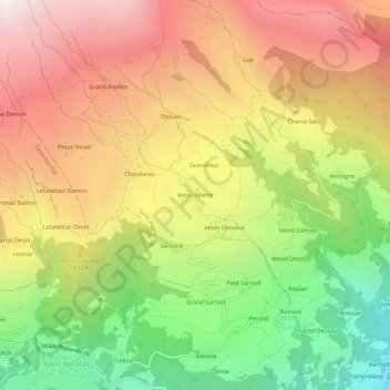
Name: Vetan Villette topographic map, elevation, terrain.
Location: Vetan Villette, Saint-Pierre, Vallée d'Aoste, 11018, Italie (45.71339 7.16695 45.75339 7.20695)
Average elevation: 1,722 m
Minimum elevation: 773 m
Maximum elevation: 2,620 m
Other topographic maps
Click on a map to view its topography, its elevation and its terrain.
Punta Leysser
Italie > Vallée d'Aoste > Saint-Pierre
Punta Leysser, Saint-Pierre, Vallée d'Aoste, Italie
Average elevation: 2,462 m