Geolocate

Koratty topographic map

Click on the map to display elevation.

About this map

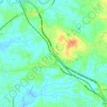
Name: Koratty topographic map, elevation, terrain.

Location: Koratty, Chalakkudy, Thrissur, Kerala, 680308, India (10.24880 76.32861 10.28880 76.36861)

Average elevation: 14 m

Minimum elevation: -2 m

Maximum elevation: 45 m

Other topographic maps

Click on a map to view its topography, its elevation and its terrain.

Thiruthiparambu East

India > Kerala > Chalakkudy > Chalakudy

Average elevation: 10 m

Lower Sholayar Dam

India > Kerala > Chalakkudy

Average elevation: 773 m

Kadukutty

India > Kerala > Chalakkudy > Sampaloor

Average elevation: 8 m

Nandipulam

India > Kerala > Chalakkudy

Average elevation: 16 m

St James Hospital

India > Kerala > Chalakkudy > Chalakudy

Average elevation: 14 m

Kuzhur

India > Kerala > Chalakkudy > Valiyaparambu

Average elevation: 7 m

Athirappilly

India > Kerala > Chalakkudy

Average elevation: 406 m

Mattathur

India > Kerala > Chalakkudy > Kodaly

Average elevation: 199 m

St James Hospital

India > Kerala > Chalakkudy > Chalakudy

Average elevation: 14 m

Kakkulissery

India > Kerala > Chalakkudy > Valiyaparambu

Average elevation: 10 m

Gear up for your next adventure:

🦶Anti-Blister Balm - Prevents friction and hotspots during long ascents
🧣Evaporative Cooling Towel - Beat the heat during intense summer climbs
🧶550 Survival Paracord - Versatile utility cord for emergency repairs and rigging
🌡️Emergency Mylar Blankets - Compact thermal protection for unexpected nights outdoors
🧼Travel Hand Sanitizer - Keep hands clean when water is scarce

As an Amazon Associate, this site earns from qualifying purchases at no extra cost to you.