Geolocate

Oakland topographic map

Click on the map to display elevation.

About this map

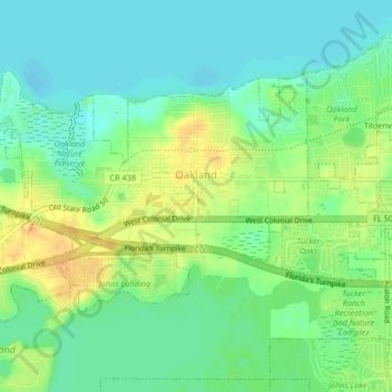
Name: Oakland topographic map, elevation, terrain.

Location: Oakland, Orange County, Florida, United States (28.54157 -81.65733 28.56472 -81.61626)

Average elevation: 28 m

Minimum elevation: 15 m

Maximum elevation: 48 m

Other topographic maps

Click on a map to view its topography, its elevation and its terrain.

Newport Park

United States > Florida > Orange County > Orlando

Average elevation: 27 m

Lake Emerald

United States > Florida > Orange County > Orlando

Average elevation: 33 m

Union Park

United States > Florida > Orange County

According to the United States Census Bureau, the CDP has a total area of 7.8 km2 (3.0 mi2), of which 7.7 km2 (3.0 mi2) is land and 0.1 km2 (0.04 mi2) (0.99%) is water. The elevation is 82 feet (25 m) above sea level.

Average elevation: 16 m

Horizon West

United States > Florida > Orange County

Average elevation: 37 m

Killarney

United States > Florida > Orange County > Oakland

Average elevation: 30 m

Lake Mann

United States > Florida > Orange County > Orlando

Average elevation: 31 m

Fairvilla

United States > Florida > Orange County

Average elevation: 31 m

Orlando

United States > Florida > Orange County

According to the Köppen climate classification, Orlando has a humid subtropical climate (Cfa) like much of the deep Southern United States. The two basic seasons in Orlando are a hot and rainy season, lasting from May until late October (roughly coinciding with the Atlantic hurricane season), and a warm and…

Average elevation: 29 m

Lake Butler

United States > Florida > Orange County

Average elevation: 33 m

Dr. Phillips

United States > Florida > Orange County

Average elevation: 36 m

Buena Vista

United States > Florida > Orange County

Average elevation: 32 m

Aloma

United States > Florida > Orange County

Average elevation: 29 m

Lake Gear

United States > Florida > Orange County > Orlando

Average elevation: 35 m

Lake Jackson

United States > Florida > Orange County > Apopka

Average elevation: 33 m

Wycliffe Park

United States > Florida > Orange County

Average elevation: 23 m

Lake Arnold

United States > Florida > Orange County > Orlando

Average elevation: 37 m

Christmas

United States > Florida > Orange County > Christmas

Average elevation: 11 m

Deer Island

United States > Florida > Orange County

Average elevation: 29 m

Union Park

United States > Florida > Orange County

According to the United States Census Bureau, the CDP has a total area of 7.8 km2 (3.0 mi2), of which 7.7 km2 (3.0 mi2) is land and 0.1 km2 (0.04 mi2) (0.99%) is water. The elevation is 82 feet (25 m) above sea level.

Average elevation: 16 m

Gear up for your next adventure:

🚑Survival Whistle - Signal for help across long distances in mountains
Tent Footprint - Protect tent floor and increase durability
🪜Heavy Duty Carabiners - Multi-use clips for securing gear to your backpack
🦶Hiking Shoe Insoles - Added support for high arches and long days on feet
🛰️Satellite Messenger - Emergency communication for areas with no cell service

As an Amazon Associate, this site earns from qualifying purchases at no extra cost to you.