
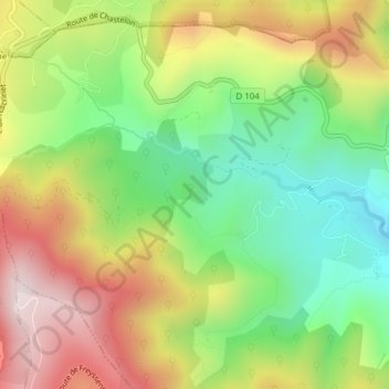
Cheylas topographic map
Interactive map
Click on the map to display elevation.
About this map
Name: Cheylas topographic map, elevation, terrain.
Average elevation: 682 m
Minimum elevation: 411 m
Maximum elevation: 1,013 m
Other topographic maps
Click on a map to view its topography, its elevation and its terrain.
Eygasses
France > Auvergne-Rhône-Alpes > Ardèche > Saint-Priest
Eygasses, Saint-Priest, Privas, Ardèche, Auvergne-Rhône-Alpes, France métropolitaine, 07000, France
Average elevation: 562 m
Bayone
France > Auvergne-Rhône-Alpes > Ardèche > Saint-Priest
Bayone, Saint-Priest, Privas, Ardèche, Auvergne-Rhône-Alpes, France métropolitaine, 07000, France
Average elevation: 764 m