
Make a donation
Gear up for your next adventure:
As an Amazon Associate, this site earns from qualifying purchases at no extra cost to you.
Tripoli District topographic map
Click on the map to display elevation.
Make a donation
Gear up for your next adventure:
As an Amazon Associate, this site earns from qualifying purchases at no extra cost to you.
About this map
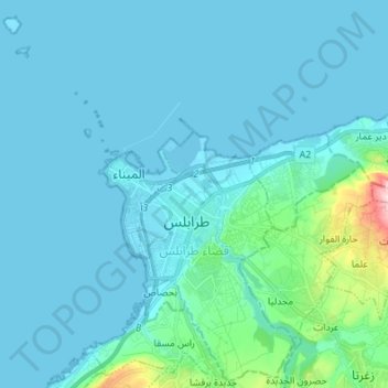
Name: Tripoli District topographic map, elevation, terrain.
Location: Tripoli District, North Governorate, Lebanon (34.39143 35.75976 34.49884 35.87343)
Average elevation: 36 m
Minimum elevation: -3 m
Maximum elevation: 355 m
Make a donation
Gear up for your next adventure:
As an Amazon Associate, this site earns from qualifying purchases at no extra cost to you.
Other topographic maps
Click on a map to view its topography, its elevation and its terrain.
Ehden
Ehden is located in the central northern side of Mount Lebanon, with a 1500-metre (at Midan square) elevation from sea level. It is 120 kilometres (75 mi) from Beirut, 30 kilometres (19 mi) from Tripoli and 25 kilometres (16 mi) from Zgharta. Ehden used to be the sole residence for Zghartians prior to the…
Average elevation: 1,350 m