
Make a donation
Gear up for your next adventure:
As an Amazon Associate, this site earns from qualifying purchases at no extra cost to you.
Rocky Point topographic map
Click on the map to display elevation.
Make a donation
Gear up for your next adventure:
As an Amazon Associate, this site earns from qualifying purchases at no extra cost to you.
About this map
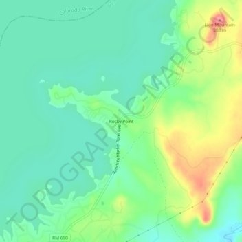
Name: Rocky Point topographic map, elevation, terrain.
Location: Rocky Point, Burnet County, Texas, United States (30.78150 -98.40206 30.82150 -98.36206)
Average elevation: 322 m
Minimum elevation: 293 m
Maximum elevation: 384 m
Make a donation
Gear up for your next adventure:
As an Amazon Associate, this site earns from qualifying purchases at no extra cost to you.
Other topographic maps
Click on a map to view its topography, its elevation and its terrain.
Make a donation
Gear up for your next adventure:
As an Amazon Associate, this site earns from qualifying purchases at no extra cost to you.
Make a donation
Gear up for your next adventure:
As an Amazon Associate, this site earns from qualifying purchases at no extra cost to you.
Double Horn
United States > Texas > Burnet County
The original settlement of Double Horn was established near the headwaters of Double Horn Creek in 1855, with the creek and town named for an incident where a pioneer found the remains of two bucks with interlocked antlers. It had a post office from 1857 to 1911, a school (the Double Horn School), a cotton…
Average elevation: 287 m