
Western Greece topographic map
Click on the map to display elevation.
About this map
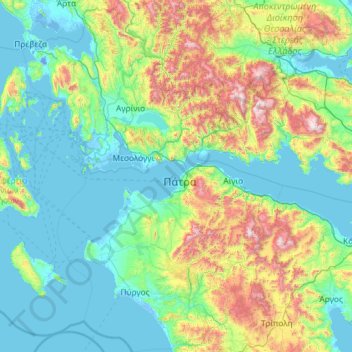
Name: Western Greece topographic map, elevation, terrain.
Average elevation: 396 m
Minimum elevation: -7 m
Maximum elevation: 2,384 m
Other topographic maps
Click on a map to view its topography, its elevation and its terrain.
Dimitsana
Greece > Peloponnese, Western Greece and the Ionian > Arcadia Regional Unit > Municipal Unit of Dimitsana
Dimitsana is built on a mountain slope at an elevation of 950 meters. From its southern side a marvelous view of Megalopolis plain and Taygetus is provided. Dimitsana is located 53 km east of Pyrgos, 31 km northwest of Tripoli, 23 km northwest of Megalopoli and 17 km northeast of Andritsaina. The village has a…
Average elevation: 1,025 m
Nafplio
Greece > Peloponnese, Western Greece and the Ionian > Argolis Regional Unit > Municipal Unit of Nafplio
Average elevation: 36 m
Chouni
Greece > Peloponnese, Western Greece and the Ionian > Aetolia-Acarnania Regional Unit > Municipal Unit of Parakampylia
Average elevation: 662 m
Xi
Greece > Peloponnese, Western Greece and the Ionian > Kefallonia Regional Unit > Paliki Municipal Unit
Average elevation: 14 m
Argos
Greece > Peloponnese, Western Greece and the Ionian > Argolis Regional Unit
Average elevation: 322 m
Zacharo
Greece > Peloponnese, Western Greece and the Ionian > Elis Regional Unit > Zacharo Municipal Unit
Average elevation: 85 m