Geolocate

Camilaca topographic map

Click on the map to display elevation.

About this map

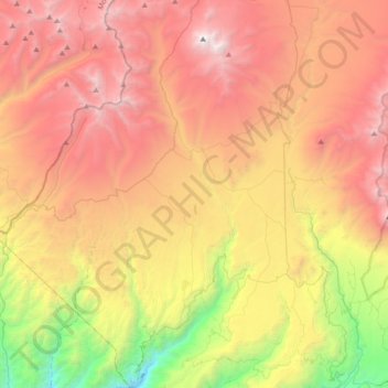
Name: Camilaca topographic map, elevation, terrain.

Location: Camilaca, Province of Candarave, Tacna, Peru (-17.33558 -70.57251 -16.99059 -70.34112)

Average elevation: 4,120 m

Minimum elevation: 2,394 m

Maximum elevation: 5,790 m

Other topographic maps

Click on a map to view its topography, its elevation and its terrain.

38

Peru > Tacna > Coronel Gregorio Albarracín Lanchipa

Average elevation: 482 m

Guanaquero

Peru > Tacna > Ilabaya

Average elevation: 3,346 m

Guanaquero

Peru > Tacna > Ilabaya

Average elevation: 3,346 m

LL

Peru > Tacna > Alto de la Alianza

Average elevation: 669 m

159

Peru > Tacna > Coronel Gregorio Albarracín Lanchipa

Average elevation: 461 m

Challamoco

Peru > Tacna > Candarave > Challamoco

Average elevation: 4,665 m

Gear up for your next adventure:

🏕️Camping Hammock - Integrated protection for sleeping between trees
🥾Waterproof Hiking Boots - Boots keeping your feet dry in wet conditions
👟Leg Gaiters - Keep debris, mud, and snow out of your boots
🥾Trekking Poles - Adjustable trekking poles to reduce knee stress and improve stability
🧼Biodegradable Camp Soap - Environmentally friendly cleaning for gear and body

As an Amazon Associate, this site earns from qualifying purchases at no extra cost to you.