
Make a donation
Gear up for your next adventure:
As an Amazon Associate, this site earns from qualifying purchases at no extra cost to you.
Georgetown topographic map
Click on the map to display elevation.
Make a donation
Gear up for your next adventure:
As an Amazon Associate, this site earns from qualifying purchases at no extra cost to you.
About this map
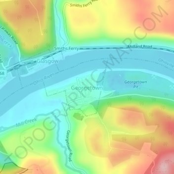
Name: Georgetown topographic map, elevation, terrain.
Location: Georgetown, Beaver County, Pennsylvania, United States (40.63701 -80.50692 40.64609 -80.49241)
Average elevation: 270 m
Minimum elevation: 200 m
Maximum elevation: 392 m
Make a donation
Gear up for your next adventure:
As an Amazon Associate, this site earns from qualifying purchases at no extra cost to you.
Other topographic maps
Click on a map to view its topography, its elevation and its terrain.
Ambridge Heights
United States > Pennsylvania > Beaver County > Harmony Township
Average elevation: 278 m
Rowtown
United States > Pennsylvania > Beaver County > South Beaver Township > Rowtown
Average elevation: 322 m
Make a donation
Gear up for your next adventure:
As an Amazon Associate, this site earns from qualifying purchases at no extra cost to you.