Riding Mountain National Park topographic map
Click on the map to display elevation.
About this map

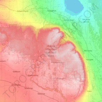
Name: Riding Mountain National Park topographic map, elevation, terrain.
Average elevation: 488 m
Minimum elevation: 258 m
Maximum elevation: 749 m
Riding Mountain Biosphere Reserve covers 15,000 square kilometers of land in South-western Manitoba, with the core area, Riding Mountain National Park (RMNP), covering nearly 3,000 square kilometers. It is some 300 km northwest of Winnipeg, Manitoba. The local climate is cool and moist due to a higher elevation than the surrounding area. Due to these unique conditions, several different ecosystems are present in the vicinity of the park, including the deciduous forest, boreal forest, and grassland.
Other topographic maps
Click on a map to view its topography, its elevation and its terrain.

Kerrs Lake
Canada > Manitoba > Division No. 15 > Municipality of Clanwilliam – Erickson
Kerrs Lake, Municipality of Clanwilliam – Erickson, Division No. 15, Manitoba, Canada
Average elevation: 670 m

Beaufort Lake
Canada > Manitoba > Division No. 15 > Municipality of Harrison Park > Sandy Lake
Beaufort Lake, Sandy Lake, Municipality of Harrison Park, Division No. 15, Manitoba, Canada
Average elevation: 613 m

Municipality of Clanwilliam – Erickson
Canada > Manitoba > Division No. 15
Municipality of Clanwilliam – Erickson, Division No. 15, Manitoba, R0J 0P0, Canada
Average elevation: 630 m

Rolling River
Canada > Manitoba > Division No. 15
Rolling River, Division No. 15, Manitoba, Canada
Average elevation: 610 m

Rural Municipality of Yellowhead
Canada > Manitoba > Division No. 15
Rural Municipality of Yellowhead, Division No. 15, Manitoba, R0J 1Z0, Canada
Average elevation: 575 m

Rural Municipality of Rosedale
Canada > Manitoba > Division No. 15
Rural Municipality of Rosedale, Division No. 15, Manitoba, R0J 0Y0, Canada
Average elevation: 484 m

Miniota
Canada > Manitoba > Division No. 15 > Prairie View Municipality
Miniota, Prairie View Municipality, Division No. 15, Manitoba, R0M 1M0, Canada
Average elevation: 440 m