Geolocate

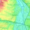
Brackenheim topographic map

Click on the map to display elevation.

About this map

Name: Brackenheim topographic map, elevation, terrain.

Location: Brackenheim, VVG der Stadt Brackenheim, Landkreis Heilbronn, Baden-Württemberg, 74336, Germany (49.04499 8.99035 49.11846 9.12576)

Average elevation: 230 m

Minimum elevation: 156 m

Maximum elevation: 388 m

Other topographic maps

Click on a map to view its topography, its elevation and its terrain.
Gear up for your next adventure:

🛁Quick-Dry Microfiber Towel - Space-saving towel that dries rapidly on the move
🛶Waterproof Dry Bags - Keep electronics and clothes dry during river crossings
⛺Camping Tent - Weather-resistant tents suitable for 2 to 6 people
🥾Trekking Poles - Adjustable trekking poles to reduce knee stress and improve stability
🩹Compact First Aid Kit - Pre-packed essentials for common trail injuries

As an Amazon Associate, this site earns from qualifying purchases at no extra cost to you.