Geolocate

Hoover topographic map

Click on the map to display elevation.

About this map

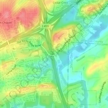
Name: Hoover topographic map, elevation, terrain.

Location: Hoover, Jefferson County, Alabama, United States (33.38626 -86.78261 33.38659 -86.78225)

Average elevation: 155 m

Minimum elevation: 121 m

Maximum elevation: 200 m

Gear up for your next adventure:

Tent Footprint - Protect tent floor and increase durability
🥘Camping Cookware Set - Compact nesting pots and pans for trail cooking
🥾Hiking Boots - Sturdy boots providing ankle support and traction on rugged trails
💧Collapsible Water Bottle - Space-saving water bottle for outdoor activities
🪑Ultralight Camping Stool - Compact seating for rest stops during long hikes

As an Amazon Associate, this site earns from qualifying purchases at no extra cost to you.