Geolocate

Mochdre topographic map

Click on the map to display elevation.

About this map

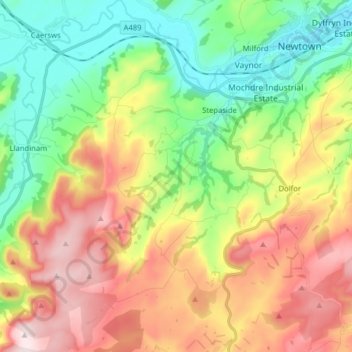
Name: Mochdre topographic map, elevation, terrain.

Location: Mochdre, Powys, Wales, United Kingdom (52.42977 -3.41339 52.52621 -3.34451)

Average elevation: 291 m

Minimum elevation: 101 m

Maximum elevation: 556 m

Other topographic maps

Click on a map to view its topography, its elevation and its terrain.

Llanidloes

United Kingdom > Wales > Powys

Average elevation: 267 m

Brecon

United Kingdom > Wales > Powys

Average elevation: 216 m

Caersws

United Kingdom > Wales > Powys

Average elevation: 145 m

Crossgates

United Kingdom > Wales > Powys

Average elevation: 225 m

Gear up for your next adventure:

🧦Thermal Socks - Warm socks for winter hiking or camping
🦌Outdoor Trail Camera - Monitor wildlife activity near your favorite spots
🧢Beanie Hat - Keep your head warm in cold weather
🧦Hiking Socks - Moisture-wicking and comfortable socks for long hikes
👟Trail Running Shoes - Agile footwear for fast-paced topographic exploration

As an Amazon Associate, this site earns from qualifying purchases at no extra cost to you.