Geolocate

Winslow topographic map

Click on the map to display elevation.

About this map

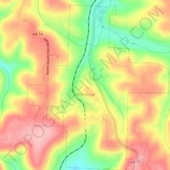
Name: Winslow topographic map, elevation, terrain.

Location: Winslow, Washington County, Arkansas, United States (35.78658 -94.14535 35.81691 -94.11406)

Average elevation: 562 m

Minimum elevation: 475 m

Maximum elevation: 628 m

Other topographic maps

Click on a map to view its topography, its elevation and its terrain.

Sunset

United States > Arkansas > Washington County

Average elevation: 628 m

Durham

United States > Arkansas > Washington County

Average elevation: 411 m

Sonora

United States > Arkansas > Washington County

Average elevation: 388 m

Pinnacle

United States > Arkansas > Washington County

Average elevation: 360 m

Canehill

United States > Arkansas > Washington County

Average elevation: 446 m

Savoy

United States > Arkansas > Washington County

Average elevation: 348 m

Strickler

United States > Arkansas > Washington County

Average elevation: 486 m

Hogeye

United States > Arkansas > Washington County

Average elevation: 414 m

Gear up for your next adventure:

🧼Biodegradable Camp Soap - Environmentally friendly cleaning for gear and body
🧦Hiking Liner Socks - Thin base layer to prevent friction and blisters
🦌Outdoor Trail Camera - Monitor wildlife activity near your favorite spots
🧴Outdoor Sunscreen - High SPF protection for high-altitude UV exposure
👟Leg Gaiters - Keep debris, mud, and snow out of your boots

As an Amazon Associate, this site earns from qualifying purchases at no extra cost to you.