Geolocate

Daraga topographic map

Click on the map to display elevation.

Daraga

67.3% of the total municipal land area has a predominantly low elevation of up to 100 metres (330 ft). The surface terrain is generally characterized by combination of level to nearly level areas, gentle to undulating areas and undulating to rolling areas.

Wikipedia (CC-BY-SA 3.0)

About this map

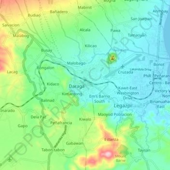
Name: Daraga topographic map, elevation, terrain.

Location: Daraga, Albay, Bicol Region, 4501, Philippines (13.10797 123.67208 13.18797 123.75208)

Average elevation: 76 m

Minimum elevation: 3 m

Maximum elevation: 266 m

Other topographic maps

Click on a map to view its topography, its elevation and its terrain.

Peñaranda Park

Philippines > Albay > Legazpi > Baño

Average elevation: 37 m

Malilipot

Philippines > Albay

Average elevation: 262 m

Rapu-Rapu

Philippines > Albay

Average elevation: 18 m

Gear up for your next adventure:

💡LED Headlamp - Hands-free illumination for night hiking and camping
🩹Compact First Aid Kit - Pre-packed essentials for common trail injuries
🦯Trekking Poles - Reduced impact on joints for steep topographic climbs
💧Filtered Water Bottle - Safe drinking water on the go
🪑Ultralight Camping Stool - Compact seating for rest stops during long hikes

As an Amazon Associate, this site earns from qualifying purchases at no extra cost to you.