
Coudures topographic map
Interactive map
Click on the map to display elevation.
About this map
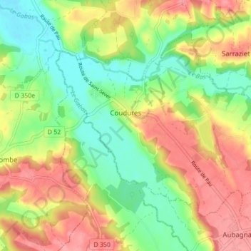
Name: Coudures topographic map, elevation, terrain.
Average elevation: 93 m
Minimum elevation: 50 m
Maximum elevation: 139 m
Other topographic maps
Click on a map to view its topography, its elevation and its terrain.
Lacquy
France > Nouvelle-Aquitaine > Landes
Lacquy, Mont-de-Marsan, Landes, Nouvelle-Aquitaine, Metropolitan France, 40120, France
Average elevation: 106 m
Saint-Avit
France > Nouvelle-Aquitaine > Landes
Saint-Avit, Mont-de-Marsan, Landes, Nouvelle-Aquitaine, Metropolitan France, 40090, France
Average elevation: 70 m
Herm
France > Nouvelle-Aquitaine > Landes
Herm, District of Dax, Landes, Nouvelle-Aquitaine, Metropolitan France, 40990, France
Average elevation: 57 m
Magescq
France > Nouvelle-Aquitaine > Landes
Magescq, District of Dax, Landes, Nouvelle-Aquitaine, Metropolitan France, 40140, France
Average elevation: 42 m
Ychoux
France > Nouvelle-Aquitaine > Landes
Ychoux, Mont-de-Marsan, Landes, Nouvelle-Aquitaine, Metropolitan France, 40160, France
Average elevation: 53 m