Geolocate

Hinigaran topographic map

Click on the map to display elevation.

About this map

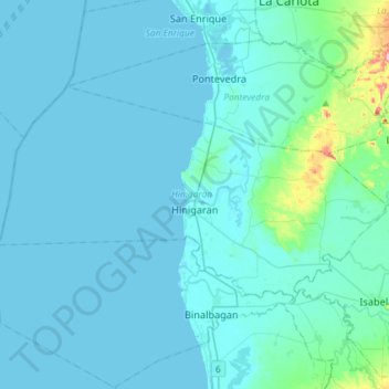
Name: Hinigaran topographic map, elevation, terrain.

Location: Hinigaran, Negros Occidental, Western Visayas, 6106, Philippines (10.20224 122.70399 10.36193 122.99499)

Average elevation: 16 m

Minimum elevation: 0 m

Maximum elevation: 219 m

Other topographic maps

Click on a map to view its topography, its elevation and its terrain.

Lumbia

Philippines > Negros Occidental > Cauayan

Average elevation: 209 m

Tagukon

Philippines > Negros Occidental > Kabankalan

Average elevation: 129 m

Concepcion

Philippines > Negros Occidental > Talisay

Average elevation: 154 m

Minoyan

Philippines > Negros Occidental > Murcia

Average elevation: 302 m

Tinagong Dagat

Philippines > Negros Occidental > Talisay

Average elevation: 1,365 m

Kabankalan

Philippines > Negros Occidental

Average elevation: 148 m

Banquerohan

Philippines > Negros Occidental > Cadiz

Average elevation: 7 m

Anahaw

Philippines > Negros Occidental > Hinigaran

Average elevation: 13 m

Tangub

Philippines > Negros Occidental > Bacolod > Tangub

Average elevation: 10 m

Central

Philippines > Negros Occidental > Sagay > Central

Average elevation: 31 m

Sibato

Philippines > Negros Occidental > Silay > Sibato

Average elevation: 260 m

Canlubang

Philippines > Negros Occidental

Average elevation: 6 m

Patag Diotay

Philippines > Negros Occidental > Silay

Average elevation: 349 m

Gear up for your next adventure:

🎒Fully Waterproof Backpack - Total protection for photography gear and electronics
🧭GPS Handheld Device - Reliable GPS navigation for outdoor adventures
💡Portable Camping Lamp - Rechargeable lamp for campsite lighting
🚲Handlebar Phone Mount - View topographic-map.com live while cycling
🧴Waterproofing Spray - Restore the DWR coating on jackets and tents

As an Amazon Associate, this site earns from qualifying purchases at no extra cost to you.