
Thank you for supporting this site ❤️
Make a donation
Make a donation
Gear up for your next adventure:
As an Amazon Associate, this site earns from qualifying purchases at no extra cost to you.
Alfaiates topographic map
Click on the map to display elevation.
Thank you for supporting this site ❤️
Make a donation
Make a donation
Gear up for your next adventure:
As an Amazon Associate, this site earns from qualifying purchases at no extra cost to you.
About this map
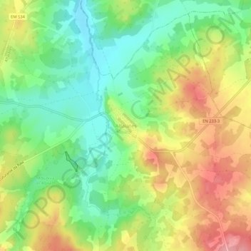
Name: Alfaiates topographic map, elevation, terrain.
Location: Alfaiates, Sabugal, Guarda, 6320-081, Portugal (40.37056 -6.93290 40.41056 -6.89290)
Average elevation: 821 m
Minimum elevation: 771 m
Maximum elevation: 882 m
Thank you for supporting this site ❤️
Make a donation
Make a donation
Gear up for your next adventure:
As an Amazon Associate, this site earns from qualifying purchases at no extra cost to you.