Geolocate

Limiñón topographic map

Click on the map to display elevation.

About this map

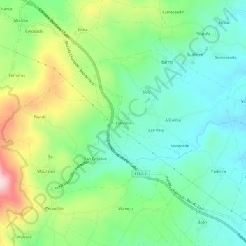
Name: Limiñón topographic map, elevation, terrain.

Location: Limiñón, Muradelle, Chantada, Lugo, Galicia, 27510, España (42.61925 -7.85467 42.65925 -7.81467)

Average elevation: 648 m

Minimum elevation: 538 m

Maximum elevation: 880 m

Other topographic maps

Click on a map to view its topography, its elevation and its terrain.

Fornas

España > Galicia > Chantada > Chantada

Average elevation: 554 m

Gear up for your next adventure:

🥾Mountaineering Boots - Supportive boots for climbing and high-altitude hiking
🧢Outdoor Visor - Breathable visor for sunny hikes
🩹Moleskin Blister Pads - Direct protection for painful foot pressure points
🥾Trail Hiking Boots - Supportive boots for rough trails
🧶550 Survival Paracord - Versatile utility cord for emergency repairs and rigging

As an Amazon Associate, this site earns from qualifying purchases at no extra cost to you.