
Майминское сельское поселение topographic map
Interactive map
Click on the map to display elevation.
About this map
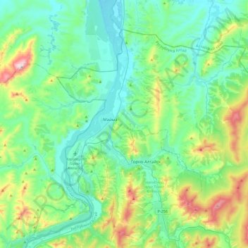
Name: Майминское сельское поселение topographic map, elevation, terrain.
Average elevation: 396 m
Minimum elevation: 234 m
Maximum elevation: 969 m
Other topographic maps
Click on a map to view its topography, its elevation and its terrain.
Каянча
Russia > Altai Republic > Mayminsky Rayon > Верх-Карагуж
Каянча, Верх-Карагуж, Майминское сельское поселение, Mayminsky Rayon, Altai Republic, Siberian Federal District, Russia
Average elevation: 349 m