
Make a donation
Gear up for your next adventure:
As an Amazon Associate, this site earns from qualifying purchases at no extra cost to you.
Erin topographic map
Click on the map to display elevation.
Make a donation
Gear up for your next adventure:
As an Amazon Associate, this site earns from qualifying purchases at no extra cost to you.
Erin
Erin is located at 36°19′1″N 87°41′53″W / 36.31694°N 87.69806°W / 36.31694; -87.69806 (36.316998, -87.697946). The elevation is 480 feet above sea level.
Make a donation
Gear up for your next adventure:
As an Amazon Associate, this site earns from qualifying purchases at no extra cost to you.
About this map
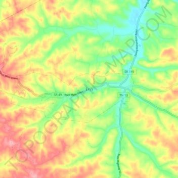
Name: Erin topographic map, elevation, terrain.
Location: Erin, Houston County, Tennessee, 37061, United States (36.27858 -87.73390 36.35858 -87.65390)
Average elevation: 173 m
Minimum elevation: 111 m
Maximum elevation: 241 m
Make a donation
Gear up for your next adventure:
As an Amazon Associate, this site earns from qualifying purchases at no extra cost to you.