
Make a donation
Gear up for your next adventure:
As an Amazon Associate, this site earns from qualifying purchases at no extra cost to you.
Lützowplatz topographic map
Click on the map to display elevation.
Make a donation
Gear up for your next adventure:
As an Amazon Associate, this site earns from qualifying purchases at no extra cost to you.
Lützowplatz
Die Schillstraße wurde auf Höhe des Platzes am 8. September 1929 ebenfalls in Lützowplatz umbenannt.
Make a donation
Gear up for your next adventure:
As an Amazon Associate, this site earns from qualifying purchases at no extra cost to you.
About this map
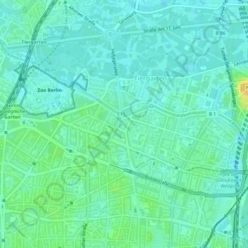
Name: Lützowplatz topographic map, elevation, terrain.
Average elevation: 40 m
Minimum elevation: 32 m
Maximum elevation: 59 m
Make a donation
Gear up for your next adventure:
As an Amazon Associate, this site earns from qualifying purchases at no extra cost to you.
Other topographic maps
Click on a map to view its topography, its elevation and its terrain.
Berlin
Deutschland > Berlin > Berlin
Die Stadt befindet sich in der gemäßigten Klimazone am Übergang vom maritimen zum kontinentalen Klima. Die durchschnittliche Jahrestemperatur in Berlin-Dahlem beträgt 9,5 °C und die mittlere jährliche Niederschlagsmenge 591 mm. Die wärmsten Monate sind Juli und August mit durchschnittlich 19,1…
Average elevation: 47 m