Geolocate

Darangan topographic map

Click on the map to display elevation.

About this map

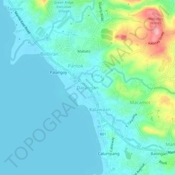
Name: Darangan topographic map, elevation, terrain.

Location: Darangan, Binangonan, Rizal, Calabarzon, 1903, Philippines (14.47029 121.16421 14.51029 121.20421)

Average elevation: 26 m

Minimum elevation: 0 m

Maximum elevation: 135 m

Other topographic maps

Click on a map to view its topography, its elevation and its terrain.

Calumpang

Philippines > Rizal > Binangonan > Macamot

Average elevation: 16 m

Libis

Philippines > Rizal > Binangonan

Average elevation: 10 m

Talim

Philippines > Rizal > Binangonan

Average elevation: 13 m

Gear up for your next adventure:

🚲Bike Repair Kit - Essential tools for on-trail mechanical issues
🪑Insulated Seat Pad - Protect your seat from cold rocks and wet logs
🥤Collapsible Travel Cup - Saves space and weight in your mess kit
👟Trail Running Shoes - Agile footwear for fast-paced topographic exploration
🛶Canoe Life Vest - Safety vest for water sports

As an Amazon Associate, this site earns from qualifying purchases at no extra cost to you.