
Thank you for supporting this site ❤️
Make a donation
Make a donation
Gear up for your next adventure:
As an Amazon Associate, this site earns from qualifying purchases at no extra cost to you.
Obertrubach topographic map
Click on the map to display elevation.
Thank you for supporting this site ❤️
Make a donation
Make a donation
Gear up for your next adventure:
As an Amazon Associate, this site earns from qualifying purchases at no extra cost to you.
About this map
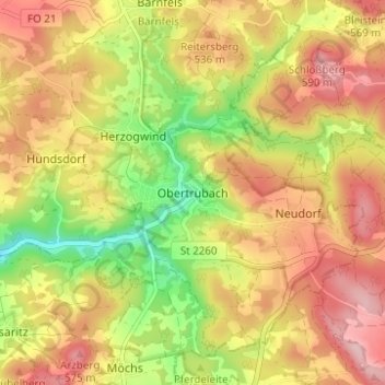
Name: Obertrubach topographic map, elevation, terrain.
Location: Obertrubach, Landkreis Forchheim, Bayern, 91286, Deutschland (49.67530 11.32969 49.71530 11.36969)
Average elevation: 504 m
Minimum elevation: 400 m
Maximum elevation: 588 m
Thank you for supporting this site ❤️
Make a donation
Make a donation
Gear up for your next adventure:
As an Amazon Associate, this site earns from qualifying purchases at no extra cost to you.