Geolocate

La Rinconada topographic map

Click on the map to display elevation.

La Rinconada

The town has gained notoriety for its extreme living conditions that include its high rates of altitude sickness, pollution, poverty, murder, and sex trafficking, and as a result has sometimes been referred to in Spanish as la ciudad sin ley del Perú, which means "the lawless city of Peru".

Wikipedia (CC-BY-SA 3.0)

About this map

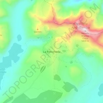
Name: La Rinconada topographic map, elevation, terrain.

Location: La Rinconada, Ananea, Province of San Antonio de Putina, Puno, Peru (-14.67416 -69.48688 -14.59416 -69.40688)

Average elevation: 4,923 m

Minimum elevation: 4,550 m

Maximum elevation: 5,834 m

Other topographic maps

Click on a map to view its topography, its elevation and its terrain.

Lake Titicaca (Peruvian sector)

Peru > Puno

Lake Titicaca has a surface elevation of 3,812 m (12,507 ft). The "highest lake" claim is generally considered to refer to commercial craft. Numerous smaller lakes around the world are at higher elevations. For many years, the largest vessel afloat on the lake was the 2,200-ton (2,425 U.S. tons), 79 m (259 ft)…

Average elevation: 4,012 m

Juliaca

Peru > Puno

Average elevation: 3,863 m

Tilali

Peru > Puno

Average elevation: 3,944 m

Juliaca

Peru > Puno

Average elevation: 3,863 m

San Juan de Salinas

Peru > Puno

Average elevation: 3,938 m

Province of Melgar

Peru > Puno

Average elevation: 4,323 m

Province of Huancané

Peru > Puno

Average elevation: 4,183 m

Taquile

Peru > Puno > Amantaní

Average elevation: 3,829 m

Juliaca

Peru > Puno

Average elevation: 3,863 m

Province of Yunguyo

Peru > Puno

Average elevation: 3,897 m

Lake Titicaca

Peru > Puno

Lake Titicaca has a surface elevation of 3,812 m (12,507 ft). The "highest navigable lake" claim is generally considered to refer to commercial craft. Numerous smaller bodies of water around the world are at higher elevations. For many years, the largest vessel afloat on the lake was the 2,200-ton (2,425 U.S.…

Average elevation: 3,870 m

Lake Titicaca (Peruvian sector)

Peru > Puno

Lake Titicaca has a surface elevation of 3,812 m (12,507 ft). The "highest lake" claim is generally considered to refer to commercial craft. Numerous smaller lakes around the world are at higher elevations. For many years, the largest vessel afloat on the lake was the 2,200-ton (2,425 U.S. tons), 79 m (259 ft)…

Average elevation: 4,012 m

Macusani

Peru > Puno > Macusani

Average elevation: 4,508 m

Laguna de Chacas

Peru > Puno > Juliaca

Average elevation: 3,894 m

Titicaca National Reserve

Peru > Puno

Average elevation: 3,843 m

Titicaca National Reserve

Peru > Puno

Average elevation: 3,843 m

Province of Lampa

Peru > Puno

Average elevation: 4,291 m

Pichacani

Peru > Puno > Pichacani

Average elevation: 4,389 m

Province of San Antonio de Putina

Peru > Puno

Average elevation: 4,299 m

Laguna Parinacota

Peru > Puno > Capazo

Average elevation: 4,235 m

Gear up for your next adventure:

🧦Hiking Liner Socks - Thin base layer to prevent friction and blisters
🧤Rechargeable Heated Gloves - Extreme warmth for Canadian winter expeditions
🗺️Topographic Maps - Detailed maps to explore trails, mountains, and wilderness areas
🔋Emergency Crank Radio - Weather alerts and power without needing batteries
🔦UV Flashlight - Detect minerals or specific insects in the dark

As an Amazon Associate, this site earns from qualifying purchases at no extra cost to you.