Geolocate

Willawong topographic map

Click on the map to display elevation.

About this map

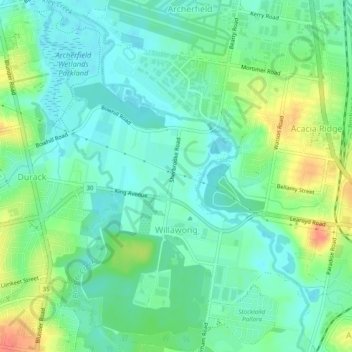
Name: Willawong topographic map, elevation, terrain.

Location: Willawong, City of Brisbane, Queensland, Australia (-27.61309 152.98679 -27.57012 153.03285)

Average elevation: 20 m

Minimum elevation: 3 m

Maximum elevation: 56 m

Other topographic maps

Click on a map to view its topography, its elevation and its terrain.

Bulimba Creek

Australia > Queensland > City of Brisbane

Average elevation: 11 m

Tangalooma

Australia > Queensland > City of Brisbane

Average elevation: 41 m

Enoggera Hill

Australia > Queensland > City of Brisbane

Average elevation: 114 m

Enoggera Dam

Australia > Queensland > City of Brisbane

Average elevation: 90 m

Blunder Creek

Australia > Queensland > City of Brisbane

Average elevation: 26 m

Tangalooma

Australia > Queensland > City of Brisbane

Average elevation: 41 m

Gear up for your next adventure:

🔨Vehicle Emergency Tool - Safety tool for remote road trips to trailheads
🥾Hiking Shoes - Durable and comfortable shoes for trail hiking
🧭GPS Tracker - Track your location in remote areas safely
🕶️Polarized Sunglasses - Reduces glare from snow and water at high elevations
💡Portable Camping Lamp - Rechargeable lamp for campsite lighting

As an Amazon Associate, this site earns from qualifying purchases at no extra cost to you.