
Thank you for supporting this site ❤️
Make a donation
Make a donation
Gear up for your next adventure:
As an Amazon Associate, this site earns from qualifying purchases at no extra cost to you.
Palasama topographic map
Click on the map to display elevation.
Thank you for supporting this site ❤️
Make a donation
Make a donation
Gear up for your next adventure:
As an Amazon Associate, this site earns from qualifying purchases at no extra cost to you.
About this map
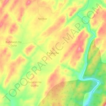
Name: Palasama topographic map, elevation, terrain.
Location: Palasama, Gogunda Tehsil, Udaipur District, Rajasthan, India (24.96586 73.45581 25.00586 73.49581)
Average elevation: 884 m
Minimum elevation: 802 m
Maximum elevation: 950 m
Thank you for supporting this site ❤️
Make a donation
Make a donation
Gear up for your next adventure:
As an Amazon Associate, this site earns from qualifying purchases at no extra cost to you.