
Make a donation
Gear up for your next adventure:
As an Amazon Associate, this site earns from qualifying purchases at no extra cost to you.
Hacıbektaş topographic map
Click on the map to display elevation.
Make a donation
Gear up for your next adventure:
As an Amazon Associate, this site earns from qualifying purchases at no extra cost to you.
Hacıbektaş
Hacıbektaş, formerly Karahöyük, is a town and district of Nevşehir Province in the Central Anatolia region of Turkey. According to 2000 census, population of the district is 11,929 of which 5,169 live in the town of Hacıbektaş. Located in Cappadocia, the district covers an area of 697 km2 (269 sq mi), and the average elevation is 1,250 m (4,101 ft), with the highest point being Mt. Kırlangıç at 1,720 m (5,643 ft). The town is named after Haji Bektash Veli, a 13th-century Sufi saint who founded the Bektashi Order.
Make a donation
Gear up for your next adventure:
As an Amazon Associate, this site earns from qualifying purchases at no extra cost to you.
About this map
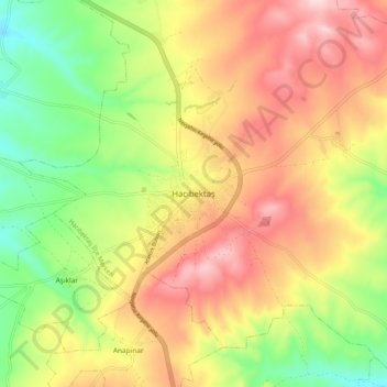
Name: Hacıbektaş topographic map, elevation, terrain.
Location: Hacıbektaş, Nevşehir, Central Anatolia Region, 50800, Turkey (38.90288 34.52088 38.98288 34.60088)
Average elevation: 1,269 m
Minimum elevation: 1,120 m
Maximum elevation: 1,419 m
Make a donation
Gear up for your next adventure:
As an Amazon Associate, this site earns from qualifying purchases at no extra cost to you.