Geolocate

Tarnos topographic map

Click on the map to display elevation.

About this map
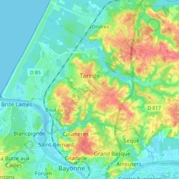
Name: Tarnos topographic map, elevation, terrain.

Location: Tarnos, District of Dax, Landes, Nouvelle-Aquitaine, Metropolitan France, 40220, France (43.49698 -1.52366 43.57054 -1.41025)

Average elevation: 19 m

Minimum elevation: -2 m

Maximum elevation: 58 m

Other topographic maps

Click on a map to view its topography, its elevation and its terrain.

Lassale

France > Nouvelle-Aquitaine > Landes > Castandet

Average elevation: 95 m

Jay

France > Nouvelle-Aquitaine > Landes > Sarbazan

Average elevation: 93 m

Sanguina

France > Nouvelle-Aquitaine > Landes > Luglon

Average elevation: 89 m

ME ?

France > Nouvelle-Aquitaine > Landes > Saint-Pierre-du-Mont

Average elevation: 90 m

Chit

France > Nouvelle-Aquitaine > Landes > Payros-Cazautets

Average elevation: 129 m

Bélida

France > Nouvelle-Aquitaine > Landes > Meilhan

Average elevation: 74 m

Milord

France > Nouvelle-Aquitaine > Landes > Mugron

Average elevation: 65 m

Le Conte

France > Nouvelle-Aquitaine > Landes > Geaune > Pichots

Average elevation: 134 m

Huron

France > Nouvelle-Aquitaine > Landes > Geaune

Average elevation: 157 m

Pabon

France > Nouvelle-Aquitaine > Landes > Garein

Average elevation: 95 m

Molin Nau

France > Nouvelle-Aquitaine > Landes > Mimizan

Average elevation: 20 m

Gear up for your next adventure:

🥘Camping Cookware Set - Compact nesting pots and pans for trail cooking
🥾Trail Running Shoes - Lightweight and durable shoes for trail running
🧤Insulated Winter Gloves - Heavy-duty protection for sub-zero Canadian adventures
🛶Waterproof Dry Bags - Keep electronics and clothes dry during river crossings
🥾Waterproof Hiking Shoes - Durable shoes for wet and rugged trails

As an Amazon Associate, this site earns from qualifying purchases at no extra cost to you.