
Oost Gelre topographic map
Interactive map
Click on the map to display elevation.
About this map
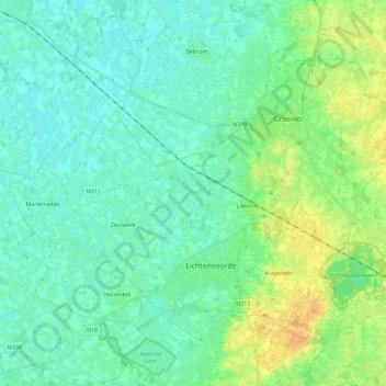
Name: Oost Gelre topographic map, elevation, terrain.
Location: Oost Gelre, Geldern, Niederlande (51.96255 6.45919 52.06804 6.68798)
Average elevation: 23 m
Minimum elevation: 15 m
Maximum elevation: 43 m
Other topographic maps
Click on a map to view its topography, its elevation and its terrain.
Lievelde
Niederlande > Geldern > Oost Gelre
Lievelde, Oost Gelre, Geldern, Niederlande
Average elevation: 24 m