Geolocate

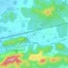
Hushu Subdistrict topographic map

Click on the map to display elevation.

About this map

Name: Hushu Subdistrict topographic map, elevation, terrain.

Location: Hushu Subdistrict, Jiangning District, Nanjing City, Jiangsu, 211126, China (31.76839 118.85767 31.92148 119.05891)

Average elevation: 14 m

Minimum elevation: 3 m

Maximum elevation: 221 m

Other topographic maps

Click on a map to view its topography, its elevation and its terrain.
裴墅

China > Jiangsu > Jiangning District > Tangshan

Average elevation: 78 m

Gear up for your next adventure:

🧢Hiking Hat - Sun-protective and breathable hats for long treks
🧢Sun Protection Cap - Breathable cap to protect from sun exposure
🚑Survival Whistle - Signal for help across long distances in mountains
🥾Waterproof Trail Shoes - Shoes designed to handle wet terrain
💡Portable Camping Lamp - Rechargeable lamp for campsite lighting

As an Amazon Associate, this site earns from qualifying purchases at no extra cost to you.