Geolocate

Chumuckla topographic map

Click on the map to display elevation.

About this map
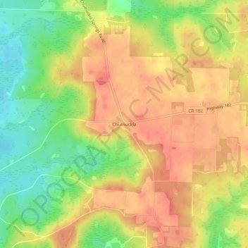
Name: Chumuckla topographic map, elevation, terrain.

Location: Chumuckla, Santa Rosa County, Florida, United States (30.75658 -87.25719 30.79658 -87.21719)

Average elevation: 49 m

Minimum elevation: 13 m

Maximum elevation: 74 m

Other topographic maps

Click on a map to view its topography, its elevation and its terrain.
Milton

United States > Florida > Santa Rosa County

Average elevation: 15 m

Pace

United States > Florida > Santa Rosa County > Pace

Average elevation: 17 m

Jay

United States > Florida > Santa Rosa County

Average elevation: 79 m

Milton

United States > Florida > Santa Rosa County

Average elevation: 15 m

Pace

United States > Florida > Santa Rosa County > Pace

Average elevation: 17 m

Pace

United States > Florida > Santa Rosa County > Pace

Average elevation: 17 m

Bagdad

United States > Florida > Santa Rosa County

Average elevation: 10 m

Pace

United States > Florida > Santa Rosa County > Pace

Average elevation: 17 m

Jay

United States > Florida > Santa Rosa County

Average elevation: 79 m

Jay

United States > Florida > Santa Rosa County

Average elevation: 79 m

Gear up for your next adventure:

🥾Approach Shoes - Shoes designed for climbing approaches and rugged trails
🔦LED Flashlight - Powerful and long-lasting flashlight for camping and emergencies
🚑Survival Whistle - Signal for help across long distances in mountains
💧Filtered Water Bottle - Safe drinking water on the go
🛶Kayak Accessories - Essential gear for safe and fun kayaking adventures

As an Amazon Associate, this site earns from qualifying purchases at no extra cost to you.