
Make a donation
Gear up for your next adventure:
As an Amazon Associate, this site earns from qualifying purchases at no extra cost to you.
Seine topographic map
Click on the map to display elevation.
Make a donation
Gear up for your next adventure:
As an Amazon Associate, this site earns from qualifying purchases at no extra cost to you.
About this map
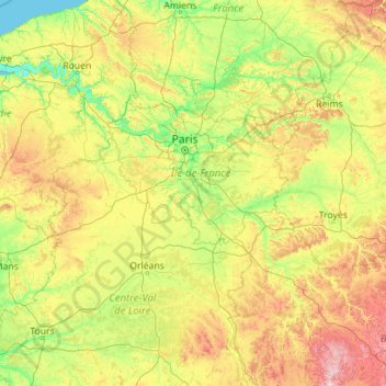
Name: Seine topographic map, elevation, terrain.
Location: Seine, Metropolitan France, France (47.48595 0.22557 49.52262 4.71698)
Average elevation: 152 m
Minimum elevation: 0 m
Maximum elevation: 833 m
Make a donation
Gear up for your next adventure:
As an Amazon Associate, this site earns from qualifying purchases at no extra cost to you.
Other topographic maps
Click on a map to view its topography, its elevation and its terrain.
Mont Ventoux
France > Provence-Alpes-Côte d'Azur > Vaucluse > Saint-Léger-du-Ventoux
There are two small ski stations on the mountain: "Mont Serein" on the north side, and "Chalet Reynard" on the south. High winds and the modest elevation tend to limit the ski season. Weather conditions are such that the northern slope is often icy, leading to a saying among people of the surrounding region…
Average elevation: 1,557 m
Make a donation
Gear up for your next adventure:
As an Amazon Associate, this site earns from qualifying purchases at no extra cost to you.
Make a donation
Gear up for your next adventure:
As an Amazon Associate, this site earns from qualifying purchases at no extra cost to you.
Curebouteille
France > Nouvelle-Aquitaine > Haute-Vienne > Oradour-sur-Vayres
Average elevation: 312 m
Make a donation
Gear up for your next adventure:
As an Amazon Associate, this site earns from qualifying purchases at no extra cost to you.
Make a donation
Gear up for your next adventure:
As an Amazon Associate, this site earns from qualifying purchases at no extra cost to you.
Ruines du Barrage de Malpasset
France > Provence-Alpes-Côte d'Azur > Var > Fréjus
Average elevation: 118 m
Make a donation
Gear up for your next adventure:
As an Amazon Associate, this site earns from qualifying purchases at no extra cost to you.
Make a donation
Gear up for your next adventure:
As an Amazon Associate, this site earns from qualifying purchases at no extra cost to you.
Make a donation
Gear up for your next adventure:
As an Amazon Associate, this site earns from qualifying purchases at no extra cost to you.
Les Ravineaux
France > Centre-Val de Loire > Indre > Villentrois-Faverolles-en-Berry
Average elevation: 131 m
Make a donation
Gear up for your next adventure:
As an Amazon Associate, this site earns from qualifying purchases at no extra cost to you.
Argentière
France > Auvergne-Rhône-Alpes > Upper Savoy > Chamonix-Mont-Blanc
Argentière (French pronunciation: [aʁʒɑ̃tjɛʁ]) is a picturesque skiing, alpine walking and mountaineering village in the French Alps, part of the commune of Chamonix-Mont-Blanc, at an altitude of 1,252 m (4,108 ft).
Average elevation: 1,674 m
Make a donation
Gear up for your next adventure:
As an Amazon Associate, this site earns from qualifying purchases at no extra cost to you.
Le Tilleul - Antifer
France > Normandy > Seine-Maritime > La Poterie-Cap-d'Antifer
Average elevation: 42 m
Make a donation
Gear up for your next adventure:
As an Amazon Associate, this site earns from qualifying purchases at no extra cost to you.
Make a donation
Gear up for your next adventure:
As an Amazon Associate, this site earns from qualifying purchases at no extra cost to you.
Méribel-Mottaret
France > Auvergne-Rhône-Alpes > Savoy > Les Allues > Méribel-Mottaret
Average elevation: 2,012 m
Collonges
France > Auvergne-Rhône-Alpes > Upper Savoy > Vétraz-Monthoux > Collonges
Average elevation: 477 m
Make a donation
Gear up for your next adventure:
As an Amazon Associate, this site earns from qualifying purchases at no extra cost to you.
Make a donation
Gear up for your next adventure:
As an Amazon Associate, this site earns from qualifying purchases at no extra cost to you.
Make a donation
Gear up for your next adventure:
As an Amazon Associate, this site earns from qualifying purchases at no extra cost to you.
Les Ansaults
France > Centre-Loire Valley > Indre-et-Loire > Artannes-sur-Indre > Les Ansaults
Average elevation: 73 m
Les Clausonnes
France > Provence-Alpes-Côte d'Azur > Maritime Alps > Valbonne > Les Clausonnes
Average elevation: 149 m
Make a donation
Gear up for your next adventure:
As an Amazon Associate, this site earns from qualifying purchases at no extra cost to you.