
Make a donation
Gear up for your next adventure:
As an Amazon Associate, this site earns from qualifying purchases at no extra cost to you.
Kahl am Main topographic map
Click on the map to display elevation.
Make a donation
Gear up for your next adventure:
As an Amazon Associate, this site earns from qualifying purchases at no extra cost to you.
Kahl am Main
Der Ort Kahl am Main liegt 107 Meter über dem Meeresspiegel. Es liegt an der Landesgrenze zu Hessen und verkehrsgünstig zwischen Aschaffenburg und Hanau (Main-Kinzig-Kreis). Der topographisch höchste Punkt der Gemeindegemarkung befindet sich nördlich von Kahl an der Birkenhainer Straße mit 130 m ü. NHN (Lage)50.1141629.036571, der niedrigste liegt im Main an der Kahlmündung auf 101,7 m ü. NHN (Lage)50.0684238.991317, welcher zugleich die tiefstgelegene Stelle in Bayern ist. Es ist die am nordwestlichsten gelegene Gemeinde Bayerns. Rund 30 Kilometer westlich liegt Frankfurt am Main.
Make a donation
Gear up for your next adventure:
As an Amazon Associate, this site earns from qualifying purchases at no extra cost to you.
About this map
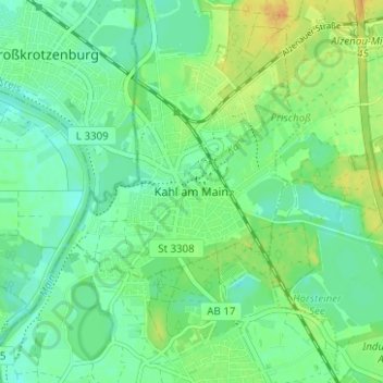
Name: Kahl am Main topographic map, elevation, terrain.
Average elevation: 112 m
Minimum elevation: 101 m
Maximum elevation: 128 m
Make a donation
Gear up for your next adventure:
As an Amazon Associate, this site earns from qualifying purchases at no extra cost to you.