Geolocate

Matanza topographic map

Click on the map to display elevation.

About this map

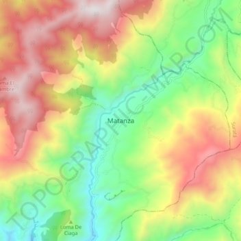
Name: Matanza topographic map, elevation, terrain.

Location: Matanza, Soto Norte, Santander, Colombia (7.28308 -73.05557 7.36308 -72.97557)

Average elevation: 2,013 m

Minimum elevation: 1,353 m

Maximum elevation: 2,834 m

Gear up for your next adventure:

🔋Lithium AA Batteries - Long-lasting power that performs in extreme cold
🛌Insulated Sleeping Pad - Critical thermal barrier between you and the cold ground
Family Camping Tent - Spacious tent suitable for family camping trips
🕶️Polarized Sunglasses - Protect your eyes with durable polarized lenses
🚲MTB Frame Bag - Carry tools and maps directly on your bicycle frame

As an Amazon Associate, this site earns from qualifying purchases at no extra cost to you.