
Thank you for supporting this site ❤️
Make a donation
Make a donation
Gear up for your next adventure:
As an Amazon Associate, this site earns from qualifying purchases at no extra cost to you.
Ecdoval topographic map
Click on the map to display elevation.
Thank you for supporting this site ❤️
Make a donation
Make a donation
Gear up for your next adventure:
As an Amazon Associate, this site earns from qualifying purchases at no extra cost to you.
About this map
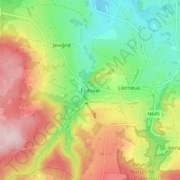
Name: Ecdoval topographic map, elevation, terrain.
Location: Ecdoval, Lierneux, Verviers, Luik, Wallonië, 4990, België (50.26527 5.75862 50.30527 5.79862)
Average elevation: 452 m
Minimum elevation: 335 m
Maximum elevation: 598 m
Thank you for supporting this site ❤️
Make a donation
Make a donation
Gear up for your next adventure:
As an Amazon Associate, this site earns from qualifying purchases at no extra cost to you.