Geolocate

Irvine topographic map

Click on the map to display elevation.

About this map

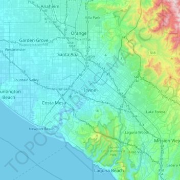
Name: Irvine topographic map, elevation, terrain.

Location: Irvine, Orange County, California, 92614, United States (33.52570 -117.98598 33.84570 -117.66598)

Average elevation: 112 m

Minimum elevation: -3 m

Maximum elevation: 914 m

Other topographic maps

Click on a map to view its topography, its elevation and its terrain.

Walnut

United States > California > Orange County > Irvine

Average elevation: 28 m

Northwood

United States > California > Orange County > Irvine

Average elevation: 54 m

Gear up for your next adventure:

💧Hydration Pack - Hands-free hydration system for long hikes
🥾Waterproof Hiking Boots - Essential footwear for rugged terrain and wet Canadian trails
💡LED Headlamp - Hands-free illumination for night hiking and camping
🚲Bike Repair Kit - Essential tools for on-trail mechanical issues
🧳Compression Sacks - Maximize space in your backpack by shrinking gear

As an Amazon Associate, this site earns from qualifying purchases at no extra cost to you.