
James Island topographic map
Click on the map to display elevation.
About this map
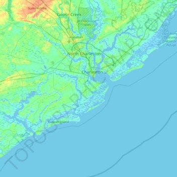
Name: James Island topographic map, elevation, terrain.
Average elevation: 3 m
Minimum elevation: -5 m
Maximum elevation: 29 m
Other topographic maps
Click on a map to view its topography, its elevation and its terrain.
Mount Pleasant
United States > South Carolina > Charleston County > Mount Pleasant
Mount Pleasant occupies a very low, gently undulating Lowcountry setting on the South Carolina Coastal Plain, where the town spreads across interfluves and former island-like uplands between the Cooper River, the Wando River, Charleston Harbor, Shem Creek, tidal creeks, and the Intracoastal Waterway. Its…
Average elevation: 3 m