
Cortes topographic map
Click on the map to display elevation.
Cortes
Ubicada a 120 kilómetros de Pamplona, en la ribera suroccidental del Ebro, el núcleo urbano está situado a una altitud de 254 metros, y el terreno del municipio es llano con algunas ondulaciones en el lugar llamado Cabezos. El Ebro discurre por el extremo nororiental del término municipal, mientras que la Huecha lo hace junto al casco urbano. Los canales de Lodosa, Tauste e Imperial de Aragón, junto con una complicada red de acequias y canales, llevan el agua hasta el último rincón, no es de extrañar por ello que sea importantísima su riqueza agrícola y sobre todo la hortícola.
About this map
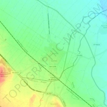
Name: Cortes topographic map, elevation, terrain.
Location: Cortes, Navarra, 31530, España (41.90353 -1.44068 41.94353 -1.40068)
Average elevation: 254 m
Minimum elevation: 234 m
Maximum elevation: 289 m