
Make a donation
Gear up for your next adventure:
As an Amazon Associate, this site earns from qualifying purchases at no extra cost to you.
Paro District topographic map
Click on the map to display elevation.
Make a donation
Gear up for your next adventure:
As an Amazon Associate, this site earns from qualifying purchases at no extra cost to you.
About this map
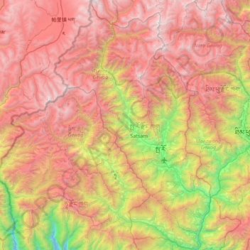
Name: Paro District topographic map, elevation, terrain.
Location: Paro District, Bhutan (27.18834 89.12806 27.78384 89.54903)
Average elevation: 3,669 m
Minimum elevation: 1,594 m
Maximum elevation: 5,747 m
Make a donation
Gear up for your next adventure:
As an Amazon Associate, this site earns from qualifying purchases at no extra cost to you.
Other topographic maps
Click on a map to view its topography, its elevation and its terrain.
Punakha
Bhutan > Punakha District > Guma Gewog > Changyuel Loongsilgang Tashijong
Punakha (Dzongkha: སྤུ་ན་ཁ་) is the administrative centre of Punakha dzongkhag, one of the 20 districts of Bhutan. Punakha was the capital of Bhutan and the seat of government until 1955, when the capital was moved to Thimphu. It is about 72 km away from Thimphu, and it takes about 3 hours by…
Average elevation: 1,623 m