
Disraeli (ville) topographic map
Interactive map
Click on the map to display elevation.
About this map
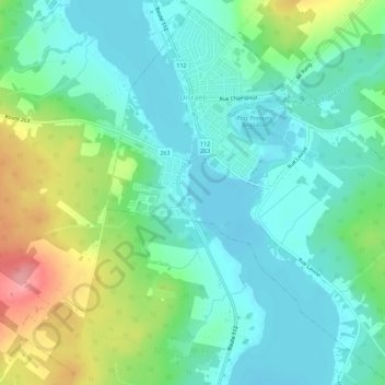
Name: Disraeli (ville) topographic map, elevation, terrain.
Average elevation: 273 m
Minimum elevation: 244 m
Maximum elevation: 347 m
Other topographic maps
Click on a map to view its topography, its elevation and its terrain.
Sainte-Praxède
Canada > Quebec > Les Appalaches
Sainte-Praxède, Les Appalaches, Chaudière-Appalaches, Quebec, Canada
Average elevation: 314 m
Vimy-Ridge
Canada > Quebec > Les Appalaches
Vimy-Ridge, Saint-Joseph-de-Coleraine, Les Appalaches, Chaudière-Appalaches, Quebec, G0N 1B0, Canada
Average elevation: 344 m
Thetford Mines
Canada > Quebec > Les Appalaches
Thetford Mines, Les Appalaches, Chaudière-Appalaches, Quebec, Canada
Average elevation: 416 m
Lac-à-la-Truite
Canada > Quebec > Les Appalaches > Thetford Mines
Lac-à-la-Truite, Thetford Mines, Les Appalaches, Chaudiere-Appalaches, Quebec, Canada
Average elevation: 426 m
Beaulac-Garthby
Canada > Quebec > Les Appalaches > Beaulac-Garthby > Beaulac-Garthby
Beaulac-Garthby, Les Appalaches, Chaudiere-Appalaches, Quebec, G0Y 1B0, Canada
Average elevation: 268 m
Lac Aylmer
Canada > Quebec > Les Appalaches > Beaulac-Garthby
Lac Aylmer, Beaulac-Garthby, Les Appalaches, Chaudière-Appalaches, Quebec, Canada
Average elevation: 314 m