Geolocate

Palestina topographic map

Click on the map to display elevation.

About this map

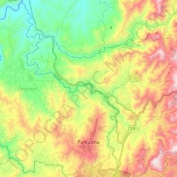
Name: Palestina topographic map, elevation, terrain.

Location: Palestina, Centrosur, Caldas, Colombia (4.99008 -75.71218 5.14053 -75.59699)

Average elevation: 1,223 m

Minimum elevation: 791 m

Maximum elevation: 1,830 m

Gear up for your next adventure:

🕶️Polarized Sunglasses - Reduces glare from snow and water at high elevations
Camping Tent - Weather-resistant tents suitable for 2 to 6 people
💡Solar Camping Lamp - Eco-friendly lighting for campsites
🔋Lithium AA Batteries - Long-lasting power that performs in extreme cold
🧭GPS Outdoor Watch - Smart watch for navigation and fitness tracking in nature

As an Amazon Associate, this site earns from qualifying purchases at no extra cost to you.