
Make a donation
Gear up for your next adventure:
As an Amazon Associate, this site earns from qualifying purchases at no extra cost to you.
Remedios topographic map
Click on the map to display elevation.
Make a donation
Gear up for your next adventure:
As an Amazon Associate, this site earns from qualifying purchases at no extra cost to you.
About this map
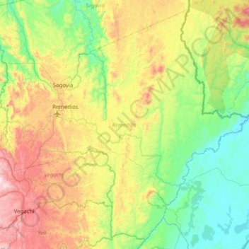
Name: Remedios topographic map, elevation, terrain.
Location: Remedios, Nordeste, Antioquia, Colombia (6.70019 -74.85729 7.26791 -74.24178)
Average elevation: 500 m
Minimum elevation: 78 m
Maximum elevation: 1,404 m
Make a donation
Gear up for your next adventure:
As an Amazon Associate, this site earns from qualifying purchases at no extra cost to you.
Other topographic maps
Click on a map to view its topography, its elevation and its terrain.
Quebrada La Quiebra
Colombia > Antioquia > Angostura > Angostura > Vereda La Culebra
Average elevation: 1,944 m
Make a donation
Gear up for your next adventure:
As an Amazon Associate, this site earns from qualifying purchases at no extra cost to you.