
Make a donation
Gear up for your next adventure:
As an Amazon Associate, this site earns from qualifying purchases at no extra cost to you.
Anchay topographic map
Click on the map to display elevation.
Make a donation
Gear up for your next adventure:
As an Amazon Associate, this site earns from qualifying purchases at no extra cost to you.
About this map
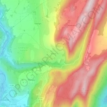
Name: Anchay topographic map, elevation, terrain.
Average elevation: 544 m
Minimum elevation: 312 m
Maximum elevation: 784 m
Make a donation
Gear up for your next adventure:
As an Amazon Associate, this site earns from qualifying purchases at no extra cost to you.
Other topographic maps
Click on a map to view its topography, its elevation and its terrain.
Saint-Hymetière
France > Bourgogne-Franche-Comté > Jura > Saint-Hymetière-sur-Valouse
Average elevation: 428 m
Chemilla
France > Bourgogne-Franche-Comté > Jura > Saint-Hymetière-sur-Valouse
Average elevation: 446 m
Cézia
France > Bourgogne-Franche-Comté > Jura > Saint-Hymetière-sur-Valouse
Cézia est un petit village situé à 496 mètres d’altitude, avec un point culminant à 680 mètres
Average elevation: 579 m