
Rebild Kommune topographic map
Interactive map
Click on the map to display elevation.
About this map
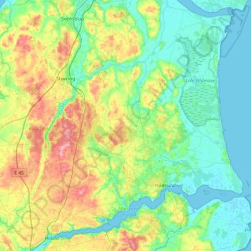
Name: Rebild Kommune topographic map, elevation, terrain.
Location: Rebild Kommune, Jutland settentrionale, Danimarca (56.65113 9.51898 56.97130 10.22812)
Average elevation: 31 m
Minimum elevation: -3 m
Maximum elevation: 116 m
Other topographic maps
Click on a map to view its topography, its elevation and its terrain.
Hjørring
Danimarca > Jutland settentrionale
Hjørring, Hjørring Kommune, Jutland settentrionale, 9800, Danimarca
Average elevation: 25 m
Aalborg
Danimarca > Jutland settentrionale
Aalborg, Aalborg Kommune, Jutland settentrionale, 9000, Danimarca
Average elevation: 17 m
Vendsyssel-Thy
Danimarca > Jutland settentrionale
Vendsyssel-Thy, Brønderslev Kommune, Jutland settentrionale, Danimarca
Average elevation: 9 m
Frederikshavn
Danimarca > Jutland settentrionale > Frederikshavn
Frederikshavn, Frederikshavn Kommune, Jutland settentrionale, 9900, Danimarca
Average elevation: 13 m