
District d'Aley topographic map
Interactive map
Click on the map to display elevation.
About this map
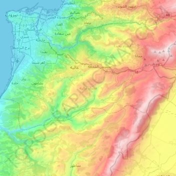
Name: District d'Aley topographic map, elevation, terrain.
Location: District d'Aley, Gouvernorat du Mont Liban, Liban (33.70245 35.45288 33.84315 35.80839)
Average elevation: 784 m
Minimum elevation: -1 m
Maximum elevation: 2,079 m
Other topographic maps
Click on a map to view its topography, its elevation and its terrain.
El Aazzouniye
Liban > District d'Aley > El Aazzouniye
El Aazzouniye, District d'Aley, Gouvernorat du Mont Liban, Liban
Average elevation: 1,183 m