
Make a donation
Gear up for your next adventure:
As an Amazon Associate, this site earns from qualifying purchases at no extra cost to you.
Big Diomede topographic map
Click on the map to display elevation.
Make a donation
Gear up for your next adventure:
As an Amazon Associate, this site earns from qualifying purchases at no extra cost to you.
Big Diomede
Big Diomede Island is located about 45 km (28 mi) southeast of Cape Dezhnev on the Chukchi Peninsula and is Russia's easternmost point. The coordinates are 65°46′52″N 169°03′25″W / 65.78111°N 169.05694°W / 65.78111; -169.05694Coordinates: 65°46′52″N 169°03′25″W / 65.78111°N 169.05694°W / 65.78111; -169.05694. The rocky tuya-type island has an area of about 29 km2 (11 sq mi) The International Date Line is about 1.3 km (0.81 mi) east of the island. The highest point of the island is at 65°46'24.64" N, 169°04'06.61" W where the elevation reaches 1,566 feet (477 m).
Make a donation
Gear up for your next adventure:
As an Amazon Associate, this site earns from qualifying purchases at no extra cost to you.
About this map
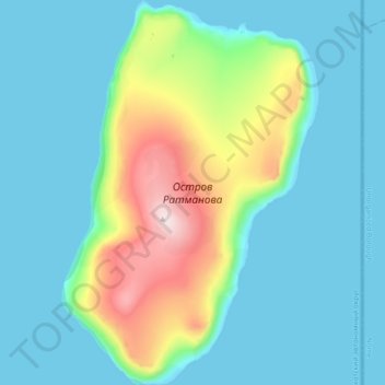
Name: Big Diomede topographic map, elevation, terrain.
Average elevation: 101 m
Minimum elevation: -1 m
Maximum elevation: 501 m
Make a donation
Gear up for your next adventure:
As an Amazon Associate, this site earns from qualifying purchases at no extra cost to you.