Geolocate

Roana topographic map

Click on the map to display elevation.

About this map

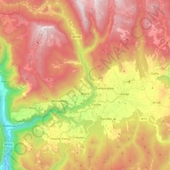
Name: Roana topographic map, elevation, terrain.

Location: Roana, Vicenza, Veneto, Italy (45.81110 11.38310 45.95447 11.49066)

Average elevation: 1,230 m

Minimum elevation: 265 m

Maximum elevation: 2,005 m

Gear up for your next adventure:

💡Solar Camping Lamp - Eco-friendly lighting for campsites
🥾Trail Hiking Shoes - Durable shoes designed for rugged trails
🦌Outdoor Trail Camera - Monitor wildlife activity near your favorite spots
🚲Bike Repair Kit - Essential tools for on-trail mechanical issues
🔭Outdoor Binoculars - Lightweight binoculars for birdwatching and hiking

As an Amazon Associate, this site earns from qualifying purchases at no extra cost to you.