Geolocate

Inala topographic map

Click on the map to display elevation.

About this map

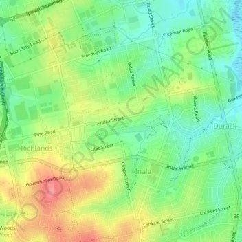
Name: Inala topographic map, elevation, terrain.

Location: Inala, Brisbane City, Queensland, 4077, Australia (-27.60924 152.95679 -27.57263 152.98821)

Average elevation: 39 m

Minimum elevation: 4 m

Maximum elevation: 87 m

Other topographic maps

Click on a map to view its topography, its elevation and its terrain.

Grange Heights

Australia > Queensland > Brisbane City

Average elevation: 34 m

Gear up for your next adventure:

🌬️Windproof Camp Stove - Efficient cooking even on exposed mountain peaks
💡Solar Camping Lamp - Eco-friendly lighting for campsites
🧰Emergency Multi-Tool - Compact multi-tool for outdoor survival
🛶Kayak Dry Bag - Waterproof storage for kayaking adventures
🩹Compact First Aid Kit - Pre-packed essentials for common trail injuries

As an Amazon Associate, this site earns from qualifying purchases at no extra cost to you.