
Make a donation
Gear up for your next adventure:
As an Amazon Associate, this site earns from qualifying purchases at no extra cost to you.
Parroquia Puerto Baquerizo Moreno topographic map
Click on the map to display elevation.
Make a donation
Gear up for your next adventure:
As an Amazon Associate, this site earns from qualifying purchases at no extra cost to you.
Parroquia Puerto Baquerizo Moreno
Puerto Baquerizo Moreno is the capital and administrative centre of Ecuador's Galápagos Province. It is located on the southwestern coast of San Cristóbal, and the town is also nicknamed Cristóbal by the local people, after the island. Its average elevation is 6 metres (20 ft). The central part of the town, including the road to El Progreso, has paved roads. The headquarters of the navy and the national police are located in the town. It has a post office, police station and hospital. A branch campus of Universidad San Francisco de Quito is situated in the town.
Make a donation
Gear up for your next adventure:
As an Amazon Associate, this site earns from qualifying purchases at no extra cost to you.
About this map
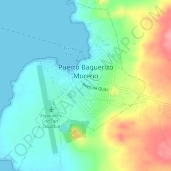
Name: Parroquia Puerto Baquerizo Moreno topographic map, elevation, terrain.
Average elevation: 35 m
Minimum elevation: 0 m
Maximum elevation: 112 m
Make a donation
Gear up for your next adventure:
As an Amazon Associate, this site earns from qualifying purchases at no extra cost to you.